Ga meteen naar de inhoud
toegevoegd aan favorieten
verwijderd uit favorieten
Helaas is er een probleem opgetreden. Probeer het opnieuw.
Uw account wordt aangemaakt
Je account is succesvol aangemaakt en je bent nu ingelogd
U bent uitgelogd
Filteren
Geselecteerde filters
    Moeilijkheidsgraad
    Duur
    Afstand in km

    Themawandelingen door Zuid-Tirol

    Overal in de vakantieregio's van Zuid-Tirol zijn bewegwijzerde themawandelingen, bijzondere ontdekkingsreizen voor jong en oud. In het Zuid-Tiroolse Unterland kunnen bezoekers in de herfst bijvoorbeeld ervaren hoe druiven van de wijnstok naar het vat gaan. In San Valentino in Campo/Gummer kun je het heelal en ons zonnestelsel verkennen en in Terlano/Terlan demonstreren aspergetelers in het voorjaar hoe de kostbare asperges uit de aarde worden gehaald. In totaal wachten meer dan 150 bewegwijzerde en informatieve themawandelingen op bezoekers van Zuid-Tirol.

    Resultaten
    Hiking
    Funimal Forest
    Ritten/Renon, Bolzano/Bozen and environs

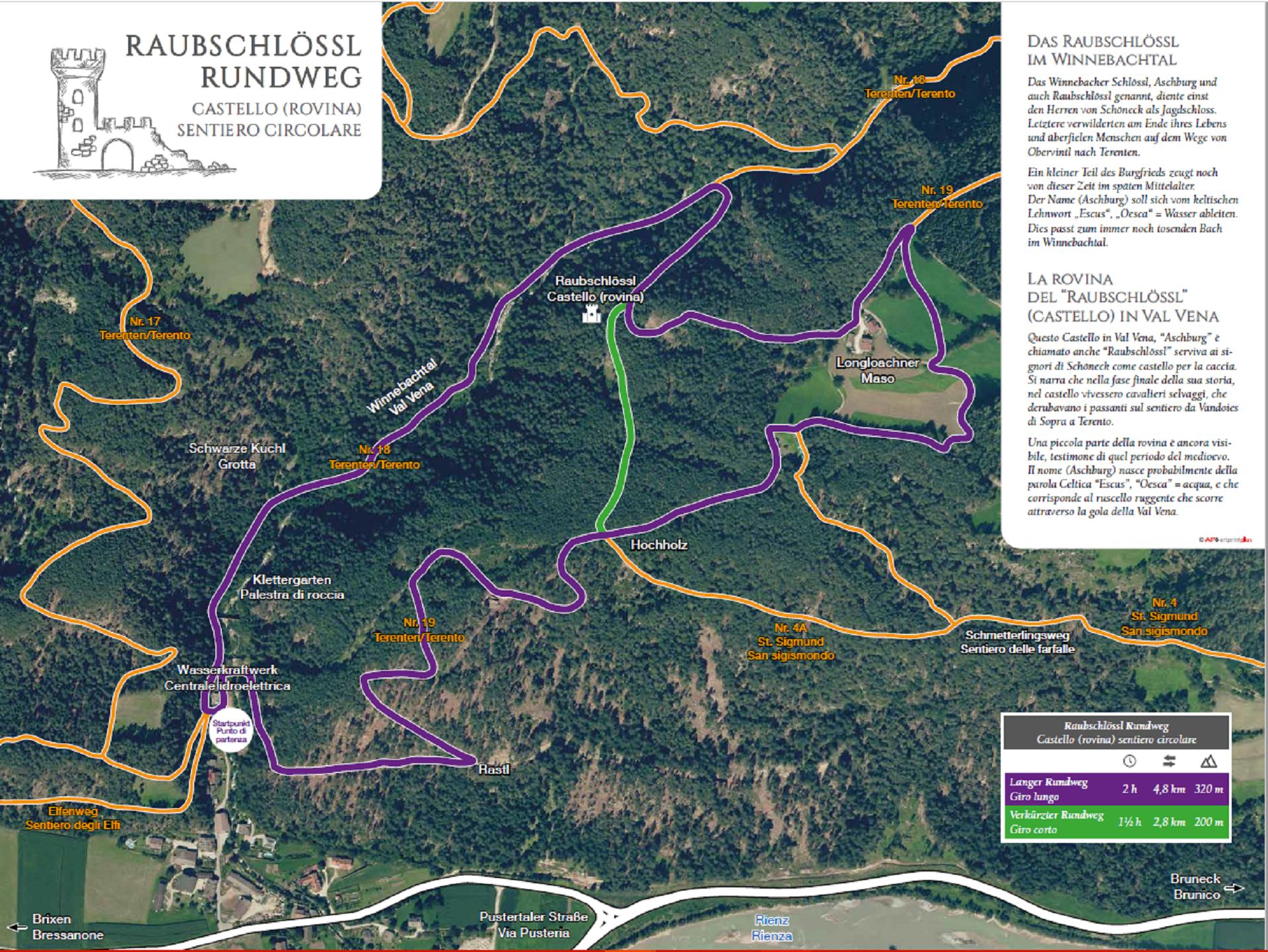
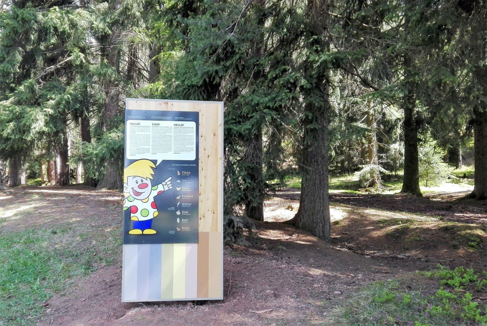
    Off we go to the special forest animals on the Ritten...
    From the Oberbozen train station we follow the small signs with the Pyramix. This awaits us at the start of the children's trail at the edge of the forest above Oberbozen and will tell us a lot about the wild animals. We can already see the first colored spots shining through the trees. I wonder what that could be? ...It's Fiona, the clever fox. She has found a great place for her den here in the forest.

    The path leads us on to Ivo, a prickly companion who is mainly found foraging at night. Well, which animal is that?

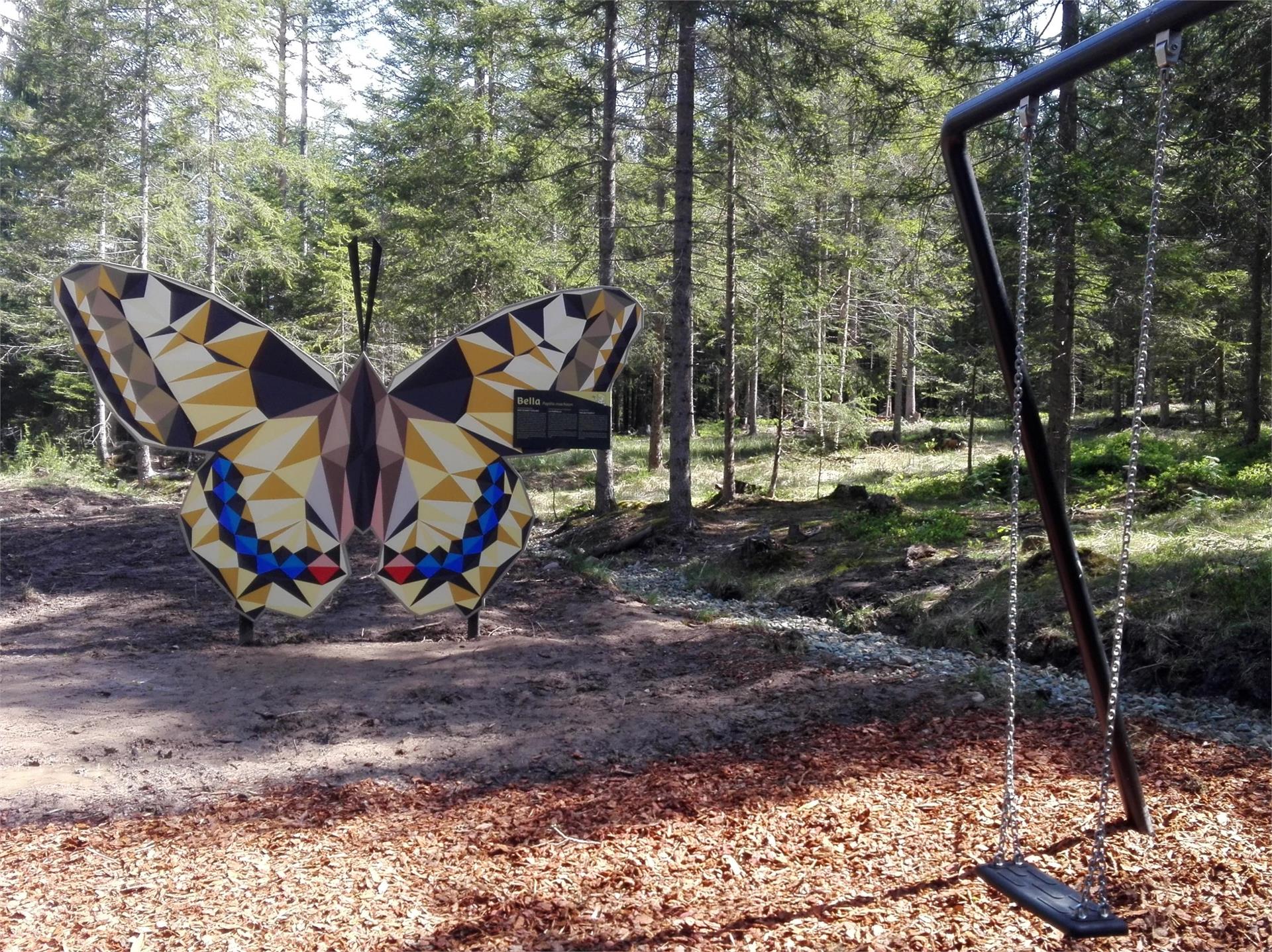
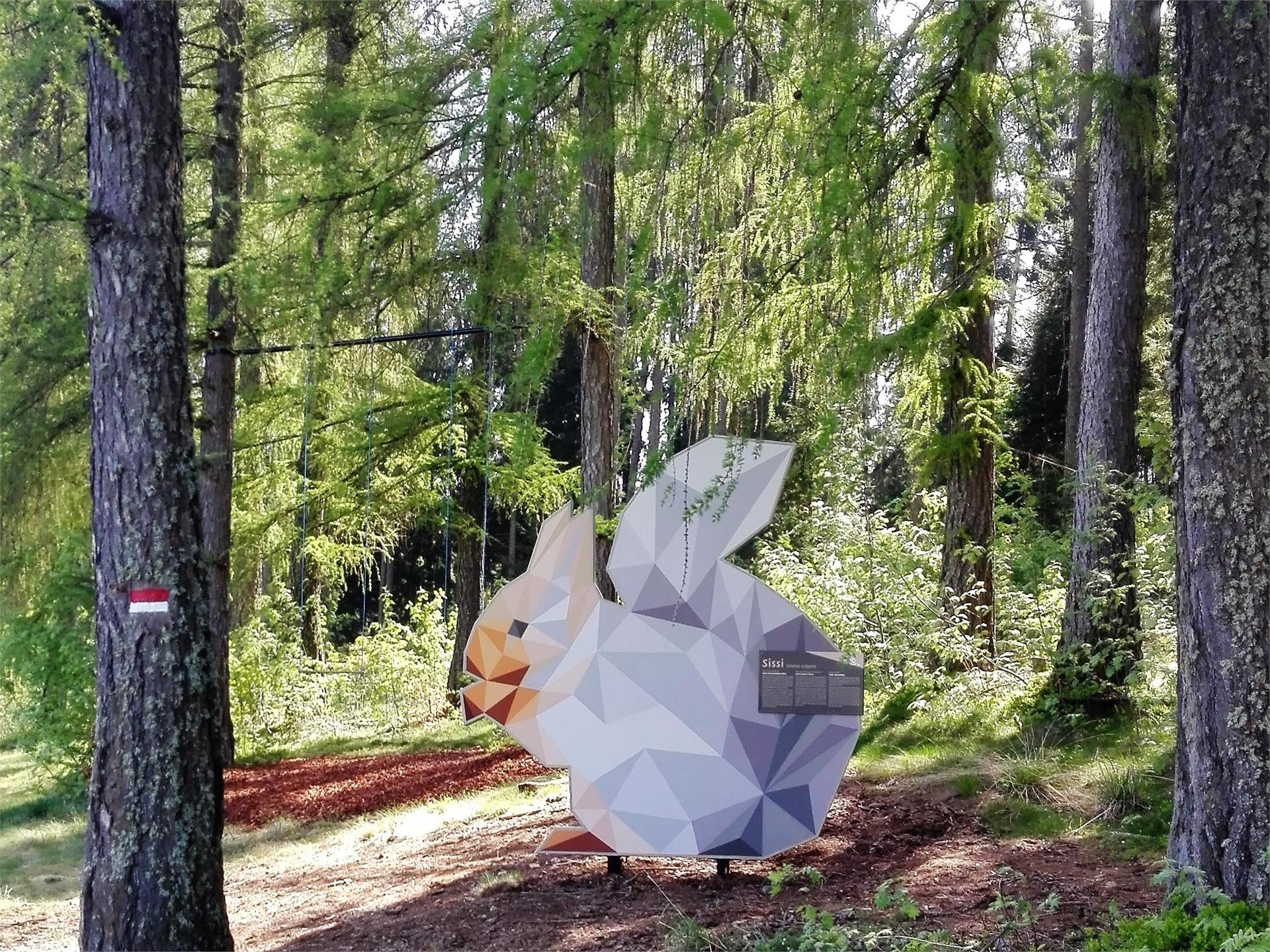
    Again and again we pass various forest and meadow dwellers. Whether it's Walter the hard-working great spotted woodpecker, who hammers a cave into the tree for his chicks with his pointed beak, or Sissi, the busy squirrel, who gathers her supplies for the winter in summer.

    At each of these stations, children will find great play opportunities that teach them about the characteristics of the animals in a playful way and, of course, there is also a description of the wild animal with its special characteristics.

    Breathing in healthy forest air and fun for young and old are guaranteed.

    Moeilijkheidsgraad: gemakkelijk
    88 Hoogtemeters
    0h:54 min Duur
    Hiking
    Knottnkino³
    Vöran/Verano, Meran/Merano and environs

    The newly-opened "Knottnkino³" circuit trail connects the three red porphyry rocks of Vöran. Starting from the Burgstall-Vöran upper cableway station, the trail leads to the three panoramic landmarks of Vöran: the Rotstein, Beimstein and Timpfler Knott.

    Moeilijkheidsgraad: gemiddeld
    416 Hoogtemeters
    4h:05 min Duur
    Hiking
    Geologic route "Höllental"
    Tramin an der Weinstraße/Termeno sulla Strada del Vino, The South Tyrolean Wine Road

    Along the geological path you will find a lot of signs and stations that shows the geology and the connected relations. The main attraction of the trail is the "Höllenbach" catastrophe of 1986. Following the path you will arrive on a big rock of tufa and the S. Nepomuk santuary. This rock last a violent mudslud and reminds the power of nature. The next sign reminds the mudslide of 1986. Just a short look to the panorama shows the different layers of rock from Montan to Weis and Schwarzhorn. Nearby you will find another rock. That's a Voltago conglomerate who resisted a mudslide 245 millions of years ago. After it there's the possibility to take a little break on a quiet island with 5 columns and a little bench with some small different rockets from the sourroundings. On the dam of the river a sign will explane you the different layers of the rock infront of you. The last sign indicate some fossils which where found in the river bed and with a bit of luck also you could find one. 

    Moeilijkheidsgraad: gemakkelijk
    135 Hoogtemeters
    0h:30 min Duur
    Hiking
    Magic path
    Kuens/Caines, Meran/Merano and environs
    The magic trail in Riffian with 20 stations invites children and adults to discover a fantastic world of magic and sorcery. It leads into the deep forest, past a wishing wheel, the labyrinth with the petrified face, eerie voices and obstacles to climb through. Once we reach the highest point, the giant magic wand awaits us, leaving nothing to be desired. On the way back, we pass a witches' village, ringing trees and a magic tunnel. With the flying carpet, we float through the gate into the children's factory town. There we can take part in building the city. After skilfully overcoming the city moat and dusting off the magic dust, "only" the experience remains. The artistically designed stations have been created from materials provided by the forest and thus contribute to the magic of the trail.
    Moeilijkheidsgraad: gemakkelijk
    137 Hoogtemeters
    0h:31 min Duur
    Hiking
    The path across the cols
    Gsies/Valle di Casies
    The history: The mountains of Defreggen Tal Valley form a big border between Val Casies Valley (I) and Villgratental Valley (A). It has always been crossed by the residents of the two valleys to trade. During the years from 1810–1814 and after the 2nd world war different goods have been smuggled across the border. Because of this the three “The path across the cols” developed. Some informative signs were arranged along the paths to tell about the history and life in earlier times.
    Moeilijkheidsgraad: gemiddeld
    870 Hoogtemeters
    4h:30 min Duur
    Hiking
    Theme path: Source of the river Drava
    Innichen/San Candido, Dolomites Region 3 Zinnen

    In the larch between Toblach/Dobbiaco and Innichen/San Candido is the source of the Drau/Drava river situated. During its 750 km long journey to the Danube the Drava flows through 5 European countries to the Black Sea.

    Further information to the water treasures of Dobbiaco like the source of the Drava River: http://www.drei-zinnen.info/en/dobbiaco/dobbiaco/experiencing-dobbiaco/lago-di-dobbiaco-lago-di-landro-and-dobbiaco-water-treasures.html

    suitable for baby stroller

    Moeilijkheidsgraad: gemakkelijk
    13 Hoogtemeters
    1h:00 min Duur
    Hiking
    Pyramid path Steinegg | Collepietra
    Karneid/Cornedo all'Isarco, Dolomites Region Eggental

    Romantic hike through forests, meadows and gorges with a view of the mighty earth pyramids, remnants from the ice age. 

    Moeilijkheidsgraad: gemiddeld
    282 Hoogtemeters
    1h:40 min Duur
    Hiking
    Informative wine trail Cortaccia Magrè Cortina
    Kurtatsch an der Weinstraße/Cortaccia sulla Strada del Vino, The South Tyrolean Wine Road

    The wine teaching trail Cortaccia/Kurtatsch | On the 1.6 km path through the vineyards of Cortaccia, hikers can trace all of the important things that happen over the course of the wine-growing year. You’ll learn about wine cultivation, landscape, and history at a number of different information stations along the way. You can also smell different aromas found in wine. | The wine teaching trail Cortaccia/Kurtatsch | Starting point: The main square of Cortaccia/Kurtatsch | Highest point: 400

    Moeilijkheidsgraad: gemiddeld
    194 Hoogtemeters
    1h:15 min Duur
    Hiking
    to the Staller Saddle (passing the Steinzger Alm hut)
    Rasen-Antholz/Rasun Anterselva, Dolomites Region Kronplatz/Plan de Corones

    Lake Antholz (1,650 m) > Steinzger cabin (1,894 m) > trail no. 7 B > Obere Steinzger Alm (2,076 m; not managed) > trail no. 7a > at the highest point (2,260 m) amazing view of both lakes and the surrounding mountain scenery > Staller Saddle / Obersee (2,050 m)

    Moeilijkheidsgraad: gemiddeld
    632 Hoogtemeters
    2h:40 min Duur
    Hiking
    Via Vinum Venostis
    Naturns/Naturno, Meran/Merano and environs

    Via Vinum Venostis in Naturno
    Circular route with 6,7 km with start in the centre of Naturno

    Moeilijkheidsgraad: gemakkelijk
    271 Hoogtemeters
    1h:55 min Duur
    Hiking
    Theme path: Sorgente "Maite"/Quellenweg
    Prags/Braies, Dolomites Region 3 Zinnen

    The new footpath in the Nature Park Fanes-Senes-Braies, where you can find one of the most beautiful source of the country. The “way of sources” is also a part of the footpath nr. 37 and easy to go. On the way you can find some wooden information-points, where the flora and the fauna are described, as well as the of drinking water. It’s werth to visit the Maite, the name of the sources.

    Moeilijkheidsgraad: gemakkelijk
    46 Hoogtemeters
    0h:31 min Duur
    Hiking
    Sluderno Biotope
    Schluderns/Sluderno, Vinschgau/Val Venosta

    These wetlands, known as Schludernser Au or Schludernser Erlenwaldbiotop alder biotope became a protected site in 1976 and cover an area of about 140 hectares. These meadowlands are the biologically most productive habitats with the greatest biodiversity. The education trail through alder woods, ponds, natural streams and rough gravel with 12 information boards in the Natura 2000 region, a veritable treasure trove of life and a refuge for endangered animals and plants.

    Moeilijkheidsgraad: gemakkelijk
    20 Hoogtemeters
    1h:00 min Duur
    Hiking
    Glittner Lake and Maurerberg circular trail
    Al Plan/San Vigilio, Dolomites Region Kronplatz/Plan de Corones
    The beautiful circular tour from Antermoia takes us via the Malga di Rina (refreshment stop) to the idyllic Lake Rina - Lé de Munt da Rina.Passing Monte Muro and the hut of the same name (possibility of refreshments) we return to Antermoia via Pé de Börz
    Moeilijkheidsgraad: zwaar
    1134 Hoogtemeters
    5h:50 min Duur
    Hiking
    Farmhouses tour in La Val
    La Val, Dolomites Region Alta Badia

    The Dolomites, with the mountains of Sasso Croce on one side and the Pütia on the other one, provide the frame for the expertly and lovingly mown and tended meadows, old barns and farmsteads with the gardens of the 'viles', the traditional rural settlements in the oldest part of La Val. During this simple walk through the old farmsteads of the village, you will feel enveloped by the still living tradition and culture of the village. In addition, on your way you will see the little church of St. Barbara, the symbol of the village, and the bell tower of the old church of La Val.

    Along the trail, there are two agritourisms, the 'Ciablun' and the 'Lüch de Survisc', where you can stop to savour the authentic and genuine dishes of the Ladin cuisine.

    Moeilijkheidsgraad: gemakkelijk
    299 Hoogtemeters
    2h:00 min Duur
    Hiking
    Nature Experience Trail Tramin
    Tramin an der Weinstraße/Termeno sulla Strada del Vino, The South Tyrolean Wine Road
    Family hike featuring beautiful views of the Lake Kaltern.
    The many display boards inform interested hikers about the diverse flora and fauna and the geological discoveries of the region, making the Nature Experience Trail in Tramin a special experience for young and old.

    From the Rathausplatz (town hall square), head along Hans-Feur-Staße street, the town’s main road, till you come to the fairground where you turn left into the Mühlgasse alley. Follow thus until turning right at a junction. After crossing over a bridge, you will see the Hotel Winzerhof.
    On the curve after the Hotel Winzerhof just follow the path 11 and walk straight ahead. The trail first leads through vineyards, then heads gently upwards through mediterranean mixed forest to the restaurant Plattenhof (closed on Monday) in Sella/Söll. On the way there are some small views on the Caldaro lake. At the Hotel Plattenhof, direction Caldaro lake, turn to the left and follow path 11A for approx 20 minutes and then leave the trail and turn to the right. After 50 minutes you will be back at Tramin.
    Moeilijkheidsgraad: gemakkelijk
    294 Hoogtemeters
    1h:55 min Duur
    Hiking
    Haflinger Adventure Trail
    Hafling/Avelengo, Meran/Merano and environs

    The Haflinger Adventure Trail, which reach from Hafling village to St. Kathrein, is dedicated to the docile and majestic Haflinger horses with their flaxen manes.

    At the didactical stations along the way, there’s plenty to learn about the Haflinger horses and how they evolved over time.

    Moeilijkheidsgraad: gemakkelijk
    63 Hoogtemeters
    0h:37 min Duur
    Hiking
    Jesus Besinnungsweg - Meditation Walk Naturno
    Naturns/Naturno, Meran/Merano and environs

    An archway decorated with a large Christogram marks the start of this pathway, which has been very carefully laid out. Each of the 15 stations is dedicated to an episode in the life of Jesus, and the surrounding landscape plays its own part in the Christian message. Also suitable for children. At every station you will find messages and thoughts on which to meditate during your walk.
    A short description of the individual stations can be obtained from the tourist office, the rectory or at the entrance to the Jesus Way of Reflection. (in german or italian language)


    Moeilijkheidsgraad: gemakkelijk
    278 Hoogtemeters
    1h:01 min Duur
    Hiking
    Planet Path
    Karneid/Cornedo all'Isarco, Dolomites Region Eggental

    By using the scale of 1:1 billion to represent the solar system, in the ‘star village’ of San Valentino in Campo it is possible to hike from Mercury to Pluto in just a few hours. 

    Moeilijkheidsgraad: gemakkelijk
    262 Hoogtemeters
    3h:00 min Duur
    Hiking
    Camino de Santiago, stage Monguelfo – Valdaora – Nessano – Brunico
    Welsberg-Taisten/Monguelfo-Tesido

    Several sections of the Pilgrim's Way Cammino di Santiago cross South Tyrol and are convincing for the variety of scenic attractions, but also for the many well-preserved reminders of the pilgrimage era along the way. You start in Monguelfo and walk to Valdaora, from there to Nessano and finally to Brunico.
    Difference in altitue ascending: 441m
    Difference in altitude descending: 695m
    Length: 21,2 km
    Walking time: 05h 51min

    Moeilijkheidsgraad: gemiddeld
    441 Hoogtemeters
    5h:50 min Duur
    Hiking
    360° Alta Val Venosta: Sluderno/Schluderns - Prato allo Stelvio/Prad am Stilfserjoch
    Prad am Stilfser Joch/Prato allo Stelvio, Vinschgau/Val Venosta

    Passing the impressive Churburg Castle is where the fifth stage of the circular hiking trail 360° Upper Vinschgau Valley starts. Probably the most beautiful view to the Ortler mountain group with the highest glacier in South Tyrol is what the stretch along the Monte Sole mountain in Vinschgau, which is rich in vegetation, has to offer.

    Moeilijkheidsgraad: gemiddeld
    361 Hoogtemeters
    3h:30 min Duur
    Hiking
    The Pinot Noir Trail
    Auer/Ora, The South Tyrolean Wine Road

    The Pinot Noir Trail in the south of South Tyrol is a new educational path where you can learn more about our land’s culture and its wines. It winds through the famed Pinot Noir vineyards and along the Trudner Horn Nature Park. It starts at the quaint villages of Auer, Montan, and Neumarkt in the Unterland district and leads you through Italy’s best Pinot Noir terroirs in Mazon, Glen, and Pinzon. You can choose between a 16-km-long one-day outing or three half-day tours.
    Along the way, hikers and strollers will encounter various historical spots and cultural highlights – e.g., the significant archeological sites of Castelfeder, the oldest segment of the Fiemme Valley railway, St. Stephan’s Church in Pinzon with its late-Gothic Altar by the Master Hans Klocker, the idyllic St. Michael’s Church in Mazon, the ruins of Kaldiff, and the handsome Enn Castle. Along the way, information panels and interactive stations will help you learn more about this unique wine-growing area and its history. You’ll be rewarded with stunning views of the Unterland district. The differences in elevation shouldn’t be a problem as most of the route is relatively level. But there’s a lot to explore and discover, for young and old alike! It’s easy, comfortable, and suitable for
    families. The route is open 12 months a year. A red “B” will lead the way.

    Moeilijkheidsgraad: gemiddeld
    607 Hoogtemeters
    4h:49 min Duur
    Hiking
    Castel Raubschlössl circular route
    Terenten/Terento, Brixen/Bressanone and environs
    A fascinating excursion awaits you in Obervintl! Start off at the church of Obervintl and follow the trail of the elves towards the hydroelectric power station. From here, you can choose between a longer route (4,8 km) and a shorter one (2,8 km). Enjoy the beauty of nature and let yourself be enchanted by this unique excursion.
    Moeilijkheidsgraad: gemiddeld
    320 Hoogtemeters
    2h:00 min Duur
    Hiking
    Gaulpromenade
    Lana, Meran/Merano and environs

    The first leisure promenade in Lana was developed into an extended trail in 1888/89 by the then Teiss landlord, Alois Stauder. From the center of the village of Lana in just a few minutes you will find yourself suddenly surrounded by the "wild" nature of the enchanting Gaulschlucht gorge; splashing water, peace & quiet, steep rock faces and rope bridges.


    Moeilijkheidsgraad: gemakkelijk
    28 Hoogtemeters
    0h:45 min Duur
    Hiking
    Pinot Noir Walkway - alternative route: Neumarkt/Egna - Mazon/Mazzon - Neumarkt/Egna
    Neumarkt/Egna, The South Tyrolean Wine Road
    The Pinot Noir walkway leads through the Pinot Nor growing area along the Trudner Horn/Monte Corno Nature Park and the characteristic villages of Auer/Ora, Montan/Montagna and Neumarkt/Egna. The Pinot Noir growing area in Montan and Mazon/Mazzon is one of the most famous in Italy. Furthermore you walk through several monuments and historical places. The walkway is family-friendly and not dangerous.
    Moeilijkheidsgraad: gemakkelijk
    228 Hoogtemeters
    1h:33 min Duur
    Hiking
    Strawberry Trail
    Martell/Martello, Vinschgau/Val Venosta

    At numerous stations, the Strawberry Trail in Val Martello demonstrates the production process of the high quality berries, leading past fields of strawberries and the farms of growers. Val Martello is not known as the “Valley of Berries” for nothing!

    Moeilijkheidsgraad: gemakkelijk
    147 Hoogtemeters
    1h:46 min Duur
    Hiking
    The Via Lucis in the Val Casies Valley
    Gsies/Valle di Casies

    Finding your self through the power of light

    Starting point: Val Casies Valley / S. Martino
    Distance: 7,1 km
    Descent: through the Karbachtal Valley
    Walking time: 02:10 h
    Difficulty: medium
    Difference in altitude: 200 m
    Information: www.suedtirolmobil.info - Lin. 441

    Moeilijkheidsgraad: gemakkelijk
    267 Hoogtemeters
    2h:06 min Duur
    Hiking
    The "Rudlbach" at Tesido
    Welsberg-Taisten/Monguelfo-Tesido

    Barefoot walking at Prati di Tesido

    Starting point: Tesido / parking lot at Prati
    Distance: 1,6 km
    Descent: along the same route
    Walking time:
    02:00 h
    Difficulty: easy
    Difference in altitude: 200 m
    Information: www.suedtirolmobil.info - Lin. 441

    Moeilijkheidsgraad: gemakkelijk
    122 Hoogtemeters
    2h:00 min Duur
    Hiking
    The Passer Gorge
    St.Leonhard in Passeier/San Leonardo in Passiria, Meran/Merano and environs

    The trail with a total length of 6.5 km goes from St. Leonhard on the left to Gomion, crosses the bridge there, and then leads to the right almost to Moos in Passeier. The trail winds along the river at water level. Halfway on, it rises in a serpentine configuration, leading through a forest and passing through a vertical wall, reaching the hamlet of Aue shortly before Moos, where the ridge again crosses the Passer river.

    The trail is not suitable forpushchairs.

    Moeilijkheidsgraad: gemiddeld
    501 Hoogtemeters
    2h:23 min Duur
    Hiking
    Hiking tour along the sun trail
    Mals/Malles, Vinschgau/Val Venosta

    Sonnensteig trail - the theme trail in Upper Vinschgau Valley

    There are some interesting points of exploration along this themed route such as the Benedictine abbey, the paths along the irrigation canals (known locally as ‘Waale’) as well as the natural landscape and some of the legends of the Alta Vinschgau Valley. And if you prefer, you can select just specific sections of the themed trail of interest to you. 

    Moeilijkheidsgraad: gemiddeld
    392 Hoogtemeters
    7h:00 min Duur
    Hiking
    The Ox Trail in the Val Casies Valley
    Gsies/Valle di Casies

    On the tracks of the of the Val Casies Valley oxen

    Starting point: Val Casies Valley / S. Maddalena head of the valley
    Distance: 6,4 km
    Descent: circular hike
    Walking time: 01:30 h – 02:00 h
    Difficulty: easy
    Difference in altitude: 200 m
    Information: www.suedtirolmobil.info - Lin. 441

    Moeilijkheidsgraad: gemakkelijk
    256 Hoogtemeters
    2h:30 min Duur
    1 2 3 4 5 6 7 8 9 10 11 12 13 14 15 16 17