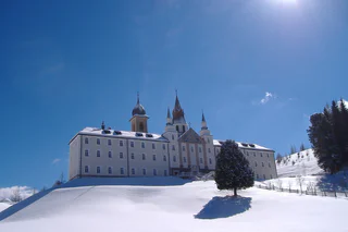
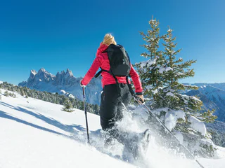
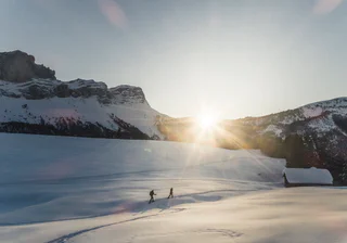
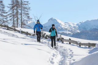
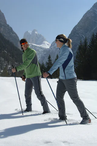
Ga meteen naar de inhoud

toegevoegd aan favorieten

verwijderd uit favorieten

Helaas is er een probleem opgetreden. Probeer het opnieuw.

Uw account wordt aangemaakt

Je account is succesvol aangemaakt en je bent nu ingelogd

U bent succesvol ingelogd!

Uw account is succesvol aangemaakt, maar we konden u niet automatisch aanmelden

U bent uitgelogd

Filteren
Geselecteerde filters
    Moeilijkheidsgraad
    Duur
    Afstand in km

    Sneeuwschoenavontuur

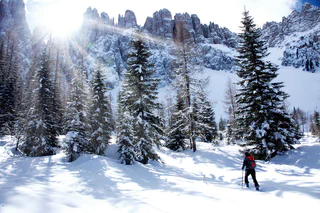
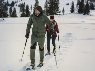
    Verken de serene winterlandschappen van de Dolomietenregio met sneeuwschoenen. Een unieke manier om van de natuur te genieten.

    Resultaten
    Hiking
    Snowshoe hike - Pragser Wildsee lake - Kaserhütte hut
    Prags/Braies, Dolomites Region 3 Zinnen

    Excursion of average difficulty in the middle of a rough and untouched nature bring you to the "Kaserhütte" hut. Starting point: Pragser Wildsee lake (1.494 m) Highest point: Kaserhütte hut (1.937 m)

    Moeilijkheidsgraad: gemiddeld
    555 m Hoogtemeters
    1h:51 min Duur
    Hiking
    Snowshoe hike from Spëscia to the Sas dla Crusc
    La Val, Dolomites Region Alta Badia

    Put on your snowshoes and set off for a magical adventure across the Armentara meadows covered in a soft and white blanket of snow. As soon as you take your first steps on the fresh snow, a unique panorama of the imposing Sas dla Crusc massif will sorround you. Once you reach the La Crusc hut, you can finally enjoy one of the typical Ladin dishes. We also recommend a visit to the highest little church in Europe, which is located just a few steps from the hut.

    Moeilijkheidsgraad: gemakkelijk
    646 m Hoogtemeters
    2h:19 min Duur
    Hiking
    Snowshoeing on Cima Lasta/Astjoch
    Kiens/Chienes, Dolomites Region Kronplatz/Plan de Corones

    The snowshoe hike on the Cima Lasta/Astjoch Peak (2,194 m) is one of the most rewarding things to do in the area. The magnificent summit view of the surrounding mountains is simply impressive.

    Before you start for a snowshoe hike you should always consult the avalanche and weather report!

    Moeilijkheidsgraad: gemiddeld
    713 m Hoogtemeters
    4h:00 min Duur
    Hiking
    Snowshoe hike to Col Toronn
    La Val, Dolomites Region Kronplatz/Plan de Corones

    Route: From the car park take the old army road up to Malga Piccolo Fanes. Up to the fork just before the Rifugio Fanes and the Rifugio Lavarella you can generally walk without snowshoes. At the fork turn right and climb across an altitude differential of approx. 100 m through the woods and across meadows (Parliament of marmots) to the plateau Plan de Serenes. From there you can see the peak of Col Toronn situated in front of the distinctive rock face of the Cima Nove. The level path leads westwards for approx. 500 m before becoming steeper, leading towards the Northwest to the ridge top that comes down from the peak of Col Toronn. Continue to climb to the right of the ridge top and in a left curve across easy terrain up to the highest point. Descent: Return by the same route to the Plan de Serenes plateau, then cross over to the South to the Rifugio Lavarella. Alternatively, return to the fork in the path and descend directly by the Rifugio Pederü.

    Moeilijkheidsgraad: zwaar
    958 m Hoogtemeters
    3h:16 min Duur
    Snowshoe Hikes
    Snowshoe tour: To the Mountain Salzla a Tesido (2131m)
    Welsberg-Taisten/Monguelfo-Tesido

    With a view towards the Dolomites

    Starting point: parking lot at Tesido above the Mudler mountain farm (1620m)
    Distance: 6,1 km
    Descent: circular hike
    Walking time: 04:00 h
    Difficulty: medium
    Difference in altitude: 525 m
    Information: also feasible with touring skis

    Moeilijkheidsgraad: gemakkelijk
    517 m Hoogtemeters
    1h:55 min Duur
    Hiking
    Snowshoe hike - Ponticello/ Brückele - Malga Rossalm/ Rossalm
    Prags/Braies, Dolomites Region 3 Zinnen

    Difficult and varied excursion on snowy routes to reach the Rossalm hut. Starting point: Brückele/Ponticello (1491 m) Highest point: Rossam hut ( 2,164 m)

    Attention: Before the start, please note the avalanche report

    Moeilijkheidsgraad: zwaar
    666 m Hoogtemeters
    2h:13 min Duur
    Snowshoe Hikes
    Snowshoe tour: To the Pfinnhütten huts in the Val Casies Valley (2152m)
    Welsberg-Taisten/Monguelfo-Tesido

    Panoramic snowshoe tour passing by the Aschtalm hut

    Starting point: Val Casies / S. Maddalena head of the valley (1465m)
    Distance: 7,5 km
    Descent: along the ascending route
    Walking time: 04:00 h
    Difficulty: difficult
    Difference in altitude: 687 m

    Moeilijkheidsgraad: gemiddeld
    663 m Hoogtemeters
    2h:16 min Duur
    Hiking
    Snowshoe hike - Brückele/Ponticello - Großer Jaufen/Giovo Grande
    Prags/Braies, Dolomites Region 3 Zinnen
    Starting from Ponticello in three hours you reach the Große Jaufen/Giovo Grande, whose snowy peak is visible from afar! Once you reach the summit, the view of the Pragser WIldsee Lake  repays every effort!
    Attention: Before the start, please note the avalanche report
    Moeilijkheidsgraad: zwaar
    982 m Hoogtemeters
    3h:15 min Duur
    Hiking
    Snowshoe hike - Pragser Wildsee lake - Grünwaldtal valley
    Prags/Braies, Dolomites Region 3 Zinnen

    Escursion of average difficulty along the right shore of Pragser Wildsee lake and enjoy the beautiful view of the Seekofel peak until the Grünwaldtal valley. Starting point: Pragser Wildsee lake(1,494 m) Arrival: Grünwaldtal valley- Jägerhütte hut (1,750 m)

    Moeilijkheidsgraad: gemiddeld
    118 m Hoogtemeters
    1h:00 min Duur
    Hiking
    Snow shoe hike from Pé de Börz to Monte Muro / Maurerberg
    San Martin /San Martino, Dolomites Region Kronplatz/Plan de Corones

    PÉ DE BÖRZ 1862 m – MONTEMURO 2332 m approx. 470 m | 2-2.5 hours Description: From the Pé de Börz car park on the road to Passo delle Erbe, take the forest trail to the Montemuro inn (closed in winter). From there, cross the ample ridge which leads to the peak. Easy hike to a safe peak with spectacular views.

    Possibility to rental snowshoes in Antermoia and Picolin.

    Moeilijkheidsgraad: gemakkelijk
    514 m Hoogtemeters
    1h:52 min Duur
    Snowshoe Hikes
    Snowshoe Tour: To the forcella di Ciarnil in the Val Casies Valley (2349m)
    Gsies/Valle di Casies

    An interesting challenge in a snow-covered alpine landscape

    Starting point: Head of the valley in St. Magdalena / Val Casies Valley 1465 m
    Descent: back via the ascent route
    Hiking time: ca. 2 ½ hours
    Level of difficulty: easy
    Altitude difference: 884 m
    Slope exposure: North Slope

    Moeilijkheidsgraad: zwaar
    884 m Hoogtemeters
    2h:30 min Duur
    Hiking
    Snow shoe hiking tour to the Bel Colle/Schönbichl
    Gais, Dolomites Region Kronplatz/Plan de Corones

    A beautiful snowshoe hike with moderate difficulty and beautiful view on the Dolomites, as well as on the main Alpine ridge and the Rieserferner peaks.

    Before you start for a snowshoe hike you should always consult the avalanche and weather report!

    Moeilijkheidsgraad: gemiddeld
    0 m Hoogtemeters
    3h:30 min Duur
    Hiking
    Snowshoe hike - St. Veit/ San Vito - Wöggenalm hut
    Prags/Braies, Dolomites Region 3 Zinnen

    Easy excursion with amazing panorama over Croda del Becco/ Seekofel and Lago di Braies/ Pragser Wildsee. Starting point: San Vito/ St. Veit(1.332m) Arrival: Malga Wöggen/ Wöggenalm (1.627m)

    Moeilijkheidsgraad: gemakkelijk
    309 m Hoogtemeters
    1h:04 min Duur
    Hiking
    Snowshoe hike - Plätzwiese high plateau - Strudelkopf peak
    Prags/Braies, Dolomites Region 3 Zinnen

    Easy excursion starting from Plätzwiese high plateau to Dürrensteinhütte hut until Strudelkopf/Monte Specie. Wonderful view over the mountains Croda Rossa, Three Peaks, Tofana and Monte Cristallo. Starting point: Plätzwiese high plateau (2,000 m) Arrival: Strudelkopf/Monte Specie (2,307 m)

    Moeilijkheidsgraad: gemiddeld
    359 m Hoogtemeters
    1h:28 min Duur
    Snowshoe Hikes
    Snowshoe Tour: Forcella di Casies/Gsieser Törl in S. Maddalena/Gsieser Tal Valley
    Gsies/Valle di Casies

    Snowshoe tour: The “Gsieser Törl” – over centuries a strategic passage for man and beast: pilgrims, smugglers, pedlars, hunters, shepherds, as well as the odd lover…

    Starting point: Head of the valley in St. Magdalena in the Gsieser Valley 1465 m
    Descent: back via the ascent route, from Kradorfer Alm left turn is also possible
    Hiking time: 2 ½ hours
    Level of difficulty: moderate to difficult; technical difficulties are minor; but last part of the climb is steep
    Altitude difference: 745 m

    Moeilijkheidsgraad: gemiddeld
    740 m Hoogtemeters
    2h:30 min Duur
    Snowshoe Hikes
    Snowshoe Tour: Along the Taistner Unterrain
    Welsberg-Taisten/Monguelfo-Tesido

    Tranquil low mountain hike – clockwise through meadows and woods of the Taistner Unterrain

    Starting point: crossroad 100 m after the Hotel Alpen Tesitin in Taisten
    Altitude difference: 260 m
    Hiking time: 2 to 3 hours
    Level of difficulty: easy and ideal terrain for snowshoe hiking
    Important: Orientation in forest difficult when leaving marked path
    Please note: this is only a snowshoe hike
    Rest point: mountain restaurant Mudler Hof

    Moeilijkheidsgraad: gemakkelijk
    315 m Hoogtemeters
    2h:10 min Duur
    Snowshoe Hikes
    Snowshoe Tour: To the Mountain Hoher Mann in the Val Casies Valley (2593m)
    Gsies/Valle di Casies

    A beautiful panorama tour across the Aschtalm, Pfinnhütten, Pfinnscharte and Hoher Mann

    Starting point: Head of the valley in St. Magdalena in the Val Caises Valley (1465 m)
    Descent: back via the ascent route
    Hiking time: ca. 3 ½ hours
    Level of difficulty: easy ski mountain that requires some endurance
    Altitude difference: 1100 m
    Slope exposure: south + east

    Moeilijkheidsgraad: gemiddeld
    1100 m Hoogtemeters
    3h:30 min Duur
    Snowshoe Hikes
    Snowshoe Tour: Rotlahner in the Val Casies Valley (2748 m)
    Gsies/Valle di Casies

    The “Rotlahner” – an easy but famous ski mountain in the Gsieser Alps

    Starting point: Head of the valley in St. Magdalena in the Gsieser Valley 1465 m
    Descent: back via the ascent route
    Hiking time: 3 ½ hours
    Level of difficulty: medium to difficult; with the exception of two steep slopes (one just beneath the Kasermähder Alm and the other in the area of the Heimwaldjoch) there are no considerable technical difficulties concerning the route
    Altitude difference: 1270 m
    Slope exposure: mainly southwest slopes

    Moeilijkheidsgraad: gemiddeld
    1270 m Hoogtemeters
    3h:30 min Duur
    Snowshoe Hikes
    Snow shoes walking at the Cima Lasta
    Kiens/Chienes, Dolomites Region Kronplatz/Plan de Corones

    The ample meadows on the Cresta di Luson-Lüsner Kamm plateau offer a never-ending choice of hiking routes. This particularly stunning one from the hamlet Elle-Ellen up to Cima Lasta-Astjoch (2147 m) boasts a number of unrivalled panoramic views. The hike/snow-shoe hike is among the most rewarding in this part of South Tyrol: The views from the peak out onto the surrounding mountains are simply unforgettable.

    Moeilijkheidsgraad: gemiddeld
    698 m Hoogtemeters
    3h:07 min Duur
    Snowshoe Hikes
    Snow shoe hiking tour at the Putzenhöe
    Kiens/Chienes, Dolomites Region Kronplatz/Plan de Corones

    The Fundres/Pfunders massif offers a wide range of hiking options with anything from soft-rolling hills to steep slopes leading up to craggy peaks. Gorgeous excursions for both summer-time hikers and winter sports fans – all topped off by breath-taking 360° panoramic views.

    Moeilijkheidsgraad: gemiddeld
    980 m Hoogtemeters
    5h:30 min Duur
    Snowshoe Hikes
    Snowshoe Tour: To the Mountain Hochkreuzspitze in Val Casies (2739m)
    Gsies/Valle di Casies

    The classic Val Casies Valley ski and snowshoe hike through the Pfoital and to the Hochkreuzspitze

    Starting point: Head of the valley in St. Magdalena in the Gsieser Valley 1465 m
    Hiking time: 4 ½ hours
    Level of difficulty: moderate – difficult; for average skiers, the route offers a wide and open terrain with only a few steep slopes that only require extra caution following fresh snow
    Altitude difference: 1274 m
    Slope exposure: southwest

    Moeilijkheidsgraad: gemiddeld
    1274 m Hoogtemeters
    4h:30 min Duur
    Hiking
    Snowshoe hike - Braies Vecchia/ Altprags - Malga Putz/ Putzalm
    Niederdorf/Villabassa, Dolomites Region 3 Zinnen

    Excursion of average difficulty in the middle of a snowy forest, marvellous proposal for those who are fond of nature. Starting point: Altprags/Braies Vecchia (1.440 m) Arrival: Putzalm (1.737 m)

    Moeilijkheidsgraad: gemiddeld
    363 m Hoogtemeters
    1h:11 min Duur
    Hiking
    Snowshoe hike - Brückele/Ponticello - Kleiner Jaufen/Giovo Piccolo
    Prags/Braies, Dolomites Region 3 Zinnen
    Challenging snowshoe hike that takes you past the Rossalm hut to the summit of the Kleiner Jaufen peak.
    Starting point: Brückele/Ponticello (1,491 m) Highest point: Kleiner Jaufen peak (2,372 m)
    Attention: Before the start, please note the avalanche report
    Moeilijkheidsgraad: zwaar
    881 m Hoogtemeters
    2h:40 min Duur
    Snowshoe Hikes
    Snowshoe tour: To the Schuier Alm in Val Casies Valley (1958m)
    Gsies/Valle di Casies

    Snowshoe tour with a panoramic view

    Starting point: Val Casies Valley/ Colle Hotel Stoll (1255m)
    Distance: 5 km
    Descent: along the ascending route
    Walking time: 03:0 h
    Difficulty: difficult
    Difference in altitude: 733 m

    Moeilijkheidsgraad: gemiddeld
    717 m Hoogtemeters
    2h:28 min Duur
    Snowshoe Hikes
    Snow shoes walking at the Sambock
    Pfalzen/Falzes, Dolomites Region Kronplatz/Plan de Corones

    Superb hiking options along the ample ridge leading up to Monte Sommo-Sambock and a singular 360° view down onto Brunico-Bruneck, the Dolomites and the Zillertal Alps.

    Moeilijkheidsgraad: gemiddeld
    887 m Hoogtemeters
    4h:00 min Duur
    Snowshoe Hikes
    Snow shoe hiking tour to the Plattner Spitze
    Mühlwald/Selva dei Molini, Dolomites Region Kronplatz/Plan de Corones
    Easy alpine pasture and summit hike. A marvellous tour with magnificent panoramic views.
    AVS awareness campaign for ski tours and snowshoe hikes:
    https://tippthek.info/t/tvkiens#/category/2544
    Moeilijkheidsgraad: gemakkelijk
    839 m Hoogtemeters
    4h:30 min Duur
    Snowshoe Hikes
    Snowshoe tour: Forcella di Casies in Val Casies (2205m)
    Gsies/Valle di Casies

    Snowshoe tour on old paths

    Starting point: Val Casies / S. Maddalena head of the valley (1465m)
    Distance: 6,1 km
    Descent: along the ascending route
    Walking time: 02:30 h
    Difficulty: difficult
    Difference in altitude: 740 m
    Information: also feasible with touring skis | southern exposure

    Moeilijkheidsgraad: gemiddeld
    740 m Hoogtemeters
    2h:30 min Duur
    1 2 3 4